
! |
This page was created by User:Dragonleaf5678 |
Avenir is the second most populous city of England with an urban area of 550 square miles and urban population of 6,785,339. Since the 19th century Avenir has been a major European cultural hub of arts, music, literature, fashion, science, and commerce. Its metropolitan area accounts for 12% of the entire British economy, in addition to being the 6th most expensive city in the world to live in, ahead of Geneva, Seoul, and Copenhagen, as well as the nation's capital.
History[]
Middle Ages and Partition of Buccleugh[]
While the name Avenir had been around since the 11th century after William the Conqueror invaded England, the current site of the city only originated around 1250, in central Buccleugh. Its situation between London and developing Worcester stapled the site as a convenient post for travellers and commerce between the two entities. With movement via boats on the rise, by the 1400s Avenir was already the fifth largest settlement in Britain, expanding from modern Blossom Hill to the current situation of Ambrose Green. Potable marshland around the crossing rivers in Avenir made agriculture prominent, lighting a steady expansion continuing to the modern day.
Avenir was de facto "founded" by the Buccleugh Order, an aristocratic family originating from France, who quickly installed a duchy in Avenir which went on to settle in lands north of its home area in modern-day South Avenir, sometime around 1267. With the northern soils being so potable and useful, populations in the north quickly began to outnumber those in the main centre of Buccleugh, becoming economically unattainable. Thus, in its ashes, Buccleugh partitioned into a number of separate duchies: Blossom Hill in the north, Ambrose Hill in the centre, Fishmarket in the east, Laving Hill in the west, Kingstanding in the south, and Falsgrave in the south-west. These newly-christened dukedoms were controlled by five sons and a daughter: the Ingomar of Blossom Hill, the Bellamy of Ambrose Hill, the Laving of Laving Hill, the Fortmont of Fishmarket, the Kingstanding of Kingstanding, and the Falsgravia of Falsgrave.
In 1440, construction of Saint Ambrose Barlow's Cathedral in central Ambrose Hill went underway as religion took its roots in Avenir. The main religious body of Avenir was Catholicism, although this waned in later years in favour of Church of England faiths.
Dukedoms of Avenir[]
With six established dukedoms in place in South Avenir, rivalry was inevitable; this was particularly manifest between the Bellamy (of Ambrose Hill) and Ingomar (of Blossom Hill) dynasties. Ambrose Hill was traditionally more populous and dense, but Blossom Hill was significantly larger and wealthier, inciting lots of troubles between the two entities. This transpired particularly between the Second Dukes of both Dynasties, who were raised into rivalry and began this tradition. Even down to religion both factions were opposed; Blossom Hill was Church of England, Ambrose Hill Catholic. Moreover, Blossom Hill was more disposed to expand into far lands, as it was on the periphery of the city; but with Ambrose Hill being trapped in the centre, this became a difficulty. Quickly these petty conflicts erupted into a series of wars and skirmishes, mostly between these two entities, thus instigating the fortress culture of early Avenir. Now all men (and even women) were encouraged to dabble into athletics and warrior culture, as it was a sign of great weakness to fall victim to either side's opposition. This constant stream of battles is often nicknamed the "Petty Wars" by the historians of today, since these major conflicts were mostly out of pride and vying.
A similar occurrence happened between Buccleugh and Falsgrave. While Buccleugh had always had more power, Falsgrave had the full backing of Pralcotte minorities, a region of Buccleugh, thus inciting a warrior culture synonymous with that in Ambrose Hill and Blossom Hill.
English Civil War[]
Avenir was a major Royalist stronghold in the English Civil War, as its part as a Cathedral City made it a major defensive outpost. The Fortress of Avenir, a mile-long stone wall stretching south of the River Severn, guarded the perimeter of the city's Cathedral as well as the major town of Ambrose Hill. Fortresses in Kingstanding and Fishmarket were also built, although they fell to the Parliamentarians soon after.
During the time of the Civil War, much of the typically belligerent and querulous city was forced to unite, though much of this lead to infighting and ultimate catastrophe on the front.
Avenir stood on the brink of Royalist control, on a large panhandle stretching from the northwest to the centre of the country. The city's number of rivers adjacent to the main front enabled a major supply line, allowing a thorough defence of the city. Avenir was sieged around twelve times between October 1642 and June 1645, where, on the latter date, alongside the Battle of Naseby, the Parliamentarians made major breakthroughs against the opposing Royalists and captured the city. The main general for the fortress, Lucas Columbine, capitulated and was executed sometime around this date, although his actual death date is unknown, as he was likely interrogated for answers.
The Fortress of Avenir still survives in remnants across Ambrose Hill and Blossom Hill, although many sections have since caved from centuries of decay.
Recovery[]
Enter the next century in 1712, the shattered city was in full momentum once again. The invention of Thomas Newcomen's Newcomen engine and the rapid modernisation of steam power increased exports and imports into the city; the development of farming methods and tools allowed sustainable produce, especially with the dawn of new fertilisers accelerating growth; the rat infestation, particularly prevalent in Fishmarket, had diminished due to the protection of crops and fishing losing its monopoly in the area; and the new constitution in England thanks to the radical Glorious Revolution of 1688 particularly outlined Fishmarket's fishing problem, limiting its users to Avenirian citizens only.
Around the same time, the hierarchy of Avenir had formed—where before many citizens were equal, delving into fishing or agricultural commerce, the growing divide between labourers and gentry and landowners was growing. By name of the latter, the land was growing increasingly expensive; the numerous benefits of Avenir made the potable land towards its centre and upon its rivers too rich for the labourers who had hitherto lived there. Organised suburbs that had been established for centuries were ripped apart by the wealthy, in favour of modern Gothic splendour. Ambrose Hill, in the centre of Avenir, turned from a quaint Tudor village into a sybaritic maze of mansions to house the wealthy, and a multitude of tall and wide streets full of big-budget shops, and, as it would later emerge, acres of dense terraced housing, where rich and poor meet their impossible collide.
Southern Conflicts[]
- Main article: Great War of the Southern Dukedoms#Timeline
The only documented conflicts in the south were those which acted as a precursor. As such, most of the battles pre-1723 (Arcanum Bellamy's ascension) are unknown.
Great War of the Southern Dukedoms[]
- Main article: Great War of the Southern Dukedoms

 Geopolitical map of Avenir in 1731 (immediate start of the war) vs 1756, after the signing of the Statute of the Union
In the shadow of the English Civil War, the dukedoms of South Avenir suffered immensely. The Great Battle of Avenir, an onslaught between attacking Parliamentarians and Royalists, shattered the fortress culture and forced the belligerent dukedoms to work together. Their loss in the Great Battle only accelerated tensions, and with an overall Parliamentarian victory in the Civil War, traditional hereditary lines of power were becoming unpopular, with the dukedoms foreseeing collapse. In a bid for power after a string of losses, Ambrose Hill rebels were able to regain their suburb, occupied by the Blossom Hill satellite, in 1726. The duke of Ambrose Hill, Arcanum Bellamy, returned under this identity and, with the full backing of the Laving Hill and Fishmarket dynasties, afraid of the rapidly-powerful dukedom, another onslaught across Blossom Hill seemed viable. With the duke reinstated, warrior culture returned in the south as a whole; Buccleugh had already abolished most of its dukedom already, undergoing disarmament, and the dukedom of Rumensholme was similarly waning. Blossom Hill was taken off-guard by the assault; Laving Hill, which was almost always neutral, had picked a side, and with the Laving Hill dynasty being the most powerful at the time, the duke of Blossom Hill abdicated. A pro-constitution revolution occurred in The Hurst, Blossom Hill, around 1730, and the Blossom Hill dukedom officially ended, with Jacob "Hurst" Hodgson poised as the new leader. A warrior by nature, he ordered his town to "defend until the end", and to "fight with all might." It was his influence which can be attributed most to Blossom Hill's power at this time. By 1731, the War had officially begun with Blossom Hill's occupation of northern Laving Hill, halted at the Laving Hill Gate. By 1732, the Laving Hill duke had abdicated, with the town falling three days later. The Duchy of Fishmarket, meanwhile, was struggling to make gains in Eastern Blossom Hill, which was heavily fortified. By this time, Buccleugh officially ended the oldest dukedom of Avenir, which had ruled from 1412 to 1732, and plead allegiance to Blossom Hill in favour of newer constitution. This meant Blossom Hill could transport assault troops to an unbeknownst Ambrose Hill, which was flanked in 1733. After 5 years of intense fighting, Ambrose Hill fell in 1736, after their supply line was finally cut in the decisive Battle for the Cathedral, where Southbank Ambrose Hill was lost, a severe blow to the power. Fishmarket, which itself had witnessed the effects of war in the East, surrendered in 1735, a year prior. The Ambrose Hill dukedom ended in 1736, setting stone for unification and constitutionalisation for the to-be city.
Unification and Constitution of Avenir[]
The terms of victory for Unionist powers in the Great War of the Southern Dukedoms included — but not limited to — the union of the dukedoms of Avenir. The duchies would be dissolved, their dukes or duchesses abdicated. This new unification would be christened "Avenir", after the moniker the Normans gave it in the 11th century. Most land borders would be established in the spite of Pro-Duchy powers, especially Ambrose Hill, which was diminished to one seventh of its original land area. Avenir would adopt general British constitution, and all satellites (including that of Blossom Hill, which was a victor in the war) would be dissolved. All areas were also forced to divide to recognise minorities; Buccleugh, the other victor of the war, split into three suburbs and gave land to the newly-former Kingstanding Town — these three suburbs became Buccleugh, Pralcotte (a minority area which fought for independence over the course of three centuries), and Rumensholme, which would house the new influx of Rumens peoples refugees in light of the recent war. Yags and Oxton-Pollock would also join the city, the latter in two components. Calderon-Ponce would also split into its respective divisions.
The Industrial Revolution[]
The shadow of the Industrial Revolution blacked the undulating hills of Avenir, like a zeppelin made of coal. The rich and wealthy exploited the cheap labour of the poor. In the 19th century alone, Avenir went from 85% agricultural to 96% industrial. Designated plots of farmland became swathes of cotton plantations, and functional thoroughfares became pretentious shopping precincts.
Due to the growing influence of the rich on the poor, jobs warranting cheap labour accounted for 30% of the city's wealth, such as in cotton plantations or manufacturing. The prevalence of entrepreneurs looking to expand into Avenir drastically increased money in the city, with sections of thereof almost entirely invested in this particular sector, particularly Holton and Fishmarket.
The second biggest industry in Avenir during this time quickly became commerce, particularly shopping; the money made by suburbia such as Blithebeth by sales alone was outstanding, combined accounting for around 40% of all monetary growth from the capital.
The next 30% is inclusive of housing and agriculture; the huge mansions in Avenir attracted swathes of the rich, generating a huge housing market defined largely by wealthy families looking for wealthy neighbourhoods. While in cities like London and Birmingham, the rich and the poor often clash, in Avenir, the poorer labourers were in pockets on the boundary of the city, far from the buzz of the rich, attracting a largely snobby, conservative audience. Agriculture still remained in the city, although mostly on the edge of the Avenir Hills in the north-west, the Redenham Hills in the south-east, and some of the preserved mires and marshland in the south-west.
Controversy and Corruption[]
The money generated by the rich in Avenir was so ludicrous, that by 1890, a few years after the very peak of industrial Avenir, the formation of any company based on cheap labour was forbidden, due to the Trade Union Act of 1871 making it much more difficult for business owners to have such a hand of power.
In Avenir, there was no balance of power; the wealthy had so much influence, they indirectly owned much of their workers. They could choose where they live, where they worked, what they owned—and this polarized hierarchy continued largely until the end of World War II when the British economy was completely destroyed. Despite the rich forming around 28% of the population, they owned 60% of the city's wealth.
The reason why this kind of disparity continued for around a century and was never stopped was because England (and later Britain) was almost entirely governed by the rich. The money generated by the labourers mostly went to the rich. There was almost no-one from a labourer background that had any kind of power; the absurd money generated by the city was only beneficial for the rich and powerful. No matter how much the poor rioted and petitioned, the rich were the only ones who "cared about them". They gave them their pay and land at the end of the day; they still fought their wars, built their roads, and, ultimately, did all the dirty work, in fear of losing it all. In almost every way, it was hopeless.
Gentrification of Avenir[]
Although a lot of this discrepancy against humanity was to generate money, many landowners and town planners were hellbent on order and architectural beauty. Despite tight laws on fishing and farming in Avenir, land could be acquired by just about anyone so long as they had the money. The biggest architect behind the Gentrification of Avenir, often nicknamed the Haussmann of Avenir, was Alfred Blithebeth. The suburb named in his honour, as well as his main brainchild, Blithebeth, is not only considered in the modern day one of the most beautiful examples of Art Nouveau architecture in the modern world but one of the most expensive, too. His brainchild was largely built on the idea of order; the modern planning of much of Victorian Avenir includes rectangular designs, with major buildings having their own plots of land encircled by roads—contrary to the majority of cities in the country, he wanted roads to be wide, a plan which has panned out to be extremely useful in a modern day obsessed with cars.
Alfred Blithebeth mainly came to power out of the extreme misbalance of power in Avenir, and also out of English competition with the French at the time. Queen Victoria herself called upon the man to build the most beautiful city he could possibly create, giving him full jurisdiction over its planning. His family included the main designer of Saint Paul's Cathedral in London, Sir Christopher Wren, as well as others.
World War I[]
Despite its being as the 2nd largest city in the United Kingdom, Avenir was merely its 4th biggest industrial contributor. After the criminalisation of cheap labour in Avenir, much of the manufacturing sector was in decline. Wealthy businessmen flocked in the majority to London, where it was still allowed. Those that stayed were—almost in entirety—the eastern belt of the City Centre, Fishmarket, and Holton, together accounting for around 96% of the city's industrial sector. Avenir's biggest production goods for the War were rifles and machine guns. The LMG, originating in Western Front combat in 1918, was invented and tested in Fishmarket. Lee-Enfield Rifles were commonly produced in Holton, as well as cheaper, disposable mortars. Uniforms were also produced in Holton. Due to Avenir's location, very few factories built vehicles such as tanks and boats due to the expense of moving them to the battlefield, with the fastest trade route being significantly further than that of London and Birmingham. That said, there were still beta stage Mark V Tanks built in the south. Most of the factories in Avenir were state-commissioned, due to the decline of privately-owned businesses after 1890.
World War II[]
One of the few major successes of the Luftwaffe Bombing Campaign was its almost total obliteration of the Avenirian War Economy. While it never fulfilled its initial objective of destroying morale and seriously denting the war effort in Britain, carpet bombing against dense industrial areas in Avenir, particularly Fishmarket, the City Centre, and Holton, wiped out Avenirian production with immediate results. Avenir had the largest warplane factory in Europe, in the Spitfire Factory in central Fishmarket, which was the largest British target Hitler had in mind. Similar to the mindset of Kaiser Wilhelm II, Hitler had a particular fondness for Avenir, as he had once visited in 1936 with his lover Eva Braun, one of their last ever major trips together as Braun led a life completely sheltered throughout World War II. He knew exactly how Avenir ran as a city; the wealthy lived in the vast, wealthy areas, and the poor lived in extreme density in the periphery of the city, herded away from the rich. The industrial perimeters of Avenir meant nothing to him, and he unleashed the first example of Luftwaffe in the city.
The 30-Day Blitz[]
The original basis for Avenir was to bomb it in broad daylight over the course of 90 days, with Luftwaffe commanders predicting this timeframe to be the most efficient way to unleash aerial arsenal over Avenir without exhausting German bombing squadrons entirely. Avenir was less specifically-packed than it was in World War I, with traditionally wealthy suburbs having to adapt to the war demands, such as Ambrose Hill and Blithebeth. German intelligence, however unaware thereof, still chose to spread out their bombing in majority across the south and centre of the city. This poor drafting meant Holton in the north would be untouched, and as such Nazi spy regimes were ordered into Avenir to inspect the industrial core, albeit poor timing (forcing bombing to start in December 1940 as opposed to its summer) stalled time. This move later ended up benefiting the campaign, however, as attitudes shifted from daylight bombing to nighttime, with the winter granting longer time slots for night air raids.
With sufficient intelligence in place, it became clear that spread-out bombing would fail to cause any significant damage, as had already been showed by the largely unsuccessful Blitz of London, and Hitler's outcry at its slowness. The Luftwaffe opted for its first ever carpet bombing on British soil, focused on completely obliterating Fishmarket, Holton, part of the City Centre, Blithebeth, Woodworth, Berkeley, Ambrose Hill, and Arendsby (at this time still part of the city centre), although the latter five never saw carpet bombing due to the expenses of its initial runs. Despite being a time of seeming rest, the 30-day consecutive bombing began on December 30, 1940, with its worst night being on January 12, 1941.
First week
At the final week of 1940, Avenir had miraculously seemed untouched. The capital's widespread destruction meant anti-aircraft guns set up in Avenir were moved due to no signs of German air assault over the city. Entirely off-guard, Fishmarket saw its first bombing run on the night of December 30, 1940, which picked out the factory land near the River Severn and its delta with the River Avon, which bombers were told to look out for. In the next six days the area around the Spitfire Factory, notable for its extreme size from the sky, was obliterated. After sheer success albeit huge ammunition expenditure, Hitler sent a fund originally intended for man-to-man combat in Poland for use in Luftwaffe in Avenir.
January 6 - 13, 1941
On January 6, carpet bombing over Holton and the eastern rim of the city centre began. Extremely delayed responses from the British war effort compensated the lives of as many as 50,000 civilians, with no major bombing shelters being established until January 9, nor any AA guns seeing circulation until the 13th. On the 12th of January, the worst night of the bombing, as much as 20% of the entire Avenirian war economy was estimated as having been obliterated. Around 8,000 civilians died in the one night, the majority of which were in Holton. Fishmarket had lost 95% of its industry by this date, leaving 60,000 people unemployed or displaced.
January 13 - January 30, 1941
The results of the first two weeks of the bombing were immediate, allowing the Luftwaffe to calm its weapon usage, amounting to 7,000 tonnes of bombs by January 13, more than half of the entire bomb expenditure of London, which occurred over 8 months. The plans to carpet bomb Blithebeth, Woodworth, Berkeley, Ambrose Hill, and Arendsby were scrapped due to extreme unsustainability after exceeding German economic limits by the 11th night. However, Hitler, impetuously ignorant of his generals, continued to push his arsenal, disciplined by no-one. The remaining nights were used to bomb the suburbs listed, cheaply using incendiary bombs to try and scorch terraced buildings across the civilian sector of the city, which incendiary bombs were effective at. This had little efficacy compared to the former nights, with the majority of the final two weeks being used to simply burn the remaining bombs designated for use over the city.
| Avenir |
Nazi Germany https://upload.wikimedia.org/wikipedia/commons/thumb/7/77/Flag_of_Germany_%281935%E2%80%931945%29.svg/23px-Flag_of_Germany_%281935%E2%80%931945%29.svg.png |
|---|---|
| Civilian: 75,000 dead
Industrial cost: £8,000,000,000 (inflation adjusted) |
Aircrew: 2,500 dead Expenditure: 44,000,000,000ℛℳ |
Post-War Avenir[]
Post-War era Avenir saw the rise of cheap housing stock alike the majority of other British urban centres. However, unlike the capital, Avenir's strict policy on rebuilding entails "complete salvaging of damaged property to minimise the architectural loss caused by bombing". All listed buildings cannot be demolished; in lieu, they have to undergo a process of deconstruction, meaning they are taken apart as opposed to being pulled down so.
While Fishmarket and Holton saw a complete transformation in the next two decades after 1945, other damaged suburbia—namely Blithebeth and Ambrose Hill—underwent expensive rebuilding and restoration attempts carried out by wealthy private landowners. Extremely tight on money, the state agreed to rebuild Holton and Fishmarket, but no more—the rebuilding of both suburbs amounted to more than £8,000,000,000 (inflation adjusted).
The industrial face of Avenir was almost completely destroyed by German shells, and it never saw recovery. The majority of displaced persons in Avenir never did return home, with the majority of council-owned housing being populated by newcomers to the city. Fishmarket's populated peaked at 200,000 in December 1940, recovering to around a fifth thereof by 2000.
Alas, while war-ravaged Avenir never did recover, inner city and suburban areas like Ambrose Hill, Blossom Hill, and Blithebeth saw drastic increases in population. Rich factory owners left Avenir after 1941, opening up room for businesses built on the fair and equal economy as opposed to cheap labour. In many ways, the city had inadvertently benefited from the war; Avenir replaced London as the business capital of western Europe, accelerating costs of living and quality of life as the council and state became increasingly invested in improving the city. This interest meant public works projects and elaborate rebuilding could go underway, as opposed to a "start-again" attitude borne by other cities. Unlike London, Avenir's population was sustained after 1950; while huge swathes of labourers and landowners left the city in favour of new towns and those still with jobs, the movement of other entities to Avenir never truly meant the city declined. The need of jobs in Avenir albeit the distaste for industrial ones ripened new business models, accelerating the job market in the city and attracting a newer population. The wealthy estates of Blithebeth were populated by fair and equal businessmen and businesswomen as opposed to tyrants. Fishmarket and Holton gained a reputation for flashy modernity, attracting a younger audience to the city.
The east city centre became a huge economic giant with a broad job market, generating so much revenue that the majority of foreign companies, including banks, instead of opting for the capital, chose Avenir.
| 1939 | 1941 | 1945 | 1950 | 1960 | 1970 | 1980 | 1990 | 2000 | 2010 | 2020 |
|---|---|---|---|---|---|---|---|---|---|---|
| 6,450,000 | 6,300,000 | 6,250,000 | 6,220,000 | 6,300,000 | 6,310,000 | 6,315,000 | 6,335,000 | 6,340,000 | 6,360,000 | 6,390,000 |
While the population in other cities has peaked since 1939, in Avenir, the rarity of cheap labour and huge recorded numbers of people leaving the city since 1941 meant the city is steadily increasing as opposed to huge bursts of growth. Avenir is projected to reach its original population peak of 6,470,000 on December 29, 1940, by 2030.
Geopolitics with the United Kingdom[]
While not officially "annexed" by the United Kingdom until the 15th century, Avenir has always acted politically independent from general British constitution. From its early years as a series of dukedoms each suburb of Avenir has had each its own ruleset which, in the case of overtly-conservative Blossom Hill, differed from British laws. After the unification, Avenir has been lead under a mayoral figure, which can run for a maximum of two terms of four years but may run again after a term-long break. In certain circumstances when political agenda have not been the biggest affair of the city, mayors have run for longer than the typical span. This was shown from the 1936-elect Adam Ravenscroft, who ran for 12 years until 1948 due to ongoing World War II at each time of his re-election.
Even if the Prime Minister and government of the United Kingdom is labour, Avenir anomalously will usually remain conservative, which it traditionally has done. Unlike anywhere else, heritage laws regarding historic buildings require permits and permission to redevelop, with deconstruction being necessary on buildings with "value"; thus forth, the retrieved useful sections of a building are then moved to either the Blithebeth or Laving Hill Vault. Avenir's policy on immigration requires a work permit; there is no law against refugees, however, due to the lack of cheap labour and an unopen job market, Avenir has reported 50 refugees from the entirety of the 2015 crisis and only 1200 total from war-torn countries from 1900. Avenir's 33% non-white population roots back to more than 150 years ago, and unlike other European industrial centres, has hardly changed since 1945. The cohesion and multiculture in Avenir achieves an extremely high index value of 0.98, showing harmony regardless of race and religion. However, Avenir, unlike the rest of the United Kingdom, has banned the burka and certain aspects of Islam regarding treatment of women.
Toponymy[]
The name Avenir is conjectured to be derived from the French term meaning future. During the Norman conquest of England, French and other Norman people settled in modern-day Blossom Hill. Ancestral remnants survive in St. Martin's Hill in Blossom Hill, which has a 13th century cottage onsite. However, its actual etymylogical origin remains a topic of debate.
Demographics[]

Throughout history, Avenir has been a major immigration centre, thanks to cheaper labour prior to World War II. Since the 1850s, it has been home to a defined profile of American, Irish, Polish, Germanic, Indian, Chinese, Japanese, and South-east Asian residents.
Much of its American and Canadian influence was around the 1880s, when the Blithebeth College of Architecture was founded, attracting a large influence of North American scholars to the city. Many of these people chose to settle in Avenir, and can be ascribed to its huge collection of Art Deco buildings in the City Centre and south city suburban areas, as well as rare Queen Anne-style Victorian buildings in Unity Lake and its surrounding areas, of which there are an extreme few in Europe. In 1922, the North American demographic composed around 7% of the total Avenirian population, its third largest ethnic group at that point. The number of these people has decreased after World War II, with obvious competition from other American and Canadian universities, but remains a strong group in Avenir.
The second largest group, being south-east Asian (inclusive of Japan and South Korea as well as China, which is listed as a separate group on the above), forms 15.9% of the population. Roughly 1 in 6 Avenirian residents are of such descent. The main roots for this group began in 1824, after British colonisation in Burma (now Myanmar), as well as in 1826 during the colonisation of Malaysia, and in 1843 after colonisation of Hong Kong. Travellers took some of the people from their travels back home in Avenir, seeing them as peers. There is no history of slavery over these people in Avenir. This continued to occur after frequent visits from Britain, developing into a steady ethnic group. After 1960 during the business revolution of Avenir, Japanese, Chinese, Singaporean, Korean, as well as more Malay and Burmese movement occurred. The room for businesses attracted these peoples, especially after many of them were poverty-stricken after civil wars, crises, or World War II.
Religion[]
Avenir is majority Christian, at an overwhelming 58% identifying thereas. 70% of Avenir's white population identify as Christians, as well as some 6% of Avenir's 33% ethnic population, many of whom are Filipino, Burmese (almost all of whom are Protestants), or African. Avenir also has the most Chinese Christians of any city outside of China or the Chinese satellite. Most Christians in Avenir are practising under Protestantism, though Catholicism is dominant in Ambrose Hill and Ambrose Green.
The next largest group regarding religion is atheism, at 20.4% of Avenir's population. Many of these have stated scepticism to religion entirely, and others agnosticism or general apathy.
The second largest religion is Hinduism. A 10% Indian population demographic, many of whom are from Hindu-dominated states of India, particularly Maharashtra. Colombo is the only suburb of Avenir whose primary religion is not Christianity, with 51% of its population being Hindu. Hinduism's total demographic is 11%.
The third largest, Buddhism, can be ascribed to a defined profile of South-East and East Asian persons living in Avenir. Burmese, east Indian, Laotian, Japanese, Chinese, and a recent surge of Vietnamese and Korean peoples are all major contributory factors of an 8% Buddhist population, a major demographical anomaly within the western world.
Islam is controversial in Avenir. Rapidly-deteriorating numbers of Islamic people in Avenir are due to the city's leadership, in certain cases, exhibiting hostility to Islam. Mayor Orenthal Hayes, revered within the city, has had an open-ended lambasting of conservative Islam, and while at no points has he officially declared Islamophobia or any xenophobia regarding Islam, on numerous occassions he has criticised its belief system. The only official "no-go zone" of Avenir, the "Colombo ghetto", was liquidated circa 2014 as one of Hayes's on-office promises. It is clear his influence has obviated Islamic immigration into Avenir, and his ban of the burka, a first for any city of the United Kingdom, also takes precedence. These factors combined mean Islam only composes 1.3% of Avenir's population. Sikhism is the next most-commonly believed, at 0.8% of the population.
The other 0.6% has an unstated religion per the Avenir Civic Council survey, such as Scientology or various Orthodox faiths.
Tourism[]


Avenir has the second largest tourism base in the United Kingdom, attracting around 5 million foreign visitors annually, giving it around the 15th most visitors of any city globally in 2015. The number of visitors can largely be ascribed to Avenir's commercial sector, with a multiplicity of exclusive stores across the city. Avenir is the most historically-preserved city with a population above 5,000,000 in the world, clinging onto around 35% of its Tudor heritage, as well as more castles than any other city in the world, with 8 major castles as well as 26 other strongholds still in condition, with ruins scattered across the city, such as the Ambrose Hill Wall.
The Avenir Tourism Trail runs from Buccleugh in the deep south to Hemisway Estate in the north-west, interchangeably. The 12-hour trip spends 6 hours in Blossom Hill, Ambrose Hill, and Blithebeth and another 2 in the City Centre, with the rest of the 4 visiting old fortifications across the south and Lake Avenir and Mount Umber in the north. The Trail is taken by around 800,000 people each year, utilising main roads, crossing the majority of landmarks save for museums which could consume hours of time. It is run by the City Council's civic division, who spends around £100,000,000 of money on tourism, with a typical 1.5x return. The city generated a total of £210,000,000 from tourism alone in 2018, whereby Blossom Hill acquired the most unique visitors, at around 3,000,000 that year, making it the third-most visited place in the United Kingdom, mostly down to its highly-famed castles, Medieval culture, castles, Art Nouveau architecture, secluded rivers, wines, and blossom trees making it a popular destination for a honeymoon. Ponce was the least visited, at only 400 visitors recorded by the Tourism Bureau in 2018.
Avenir's top 10 tourism hotspots were (as per the Avenir Tourism Bureau):
- Blossom Hill Old Town: 2,000,000 unique visitors each year
- Ambrose Hill Old Town and Cathedral Walls: 2,000,000 unique visitors each year
- Blithebeth Centre (including Eurasian Heritage Museum and Billionaire's Row): 1,950,000 unique visitors each year
- Hyphen Heights in the City Centre: 1,850,000 unique visitors each year
- Umber West village of Arte and Mount Umber: 1,700,000 unique visitors each year
- Sisefield Film Studios: 1,650,000 visitors each year
- Laving Hill Museum of World War II: 1,500,000 unique visitors each year
- Vancouver Lake Avenir: 1,000,000 unique visitors each year
- Buccleugh Village and castle fortifications: 850,000 unique visitors each year
- Hemisway Estate Resort Park and Slots: 600,000 unique visitors each year
Heritage[]
UNESCO recognised World Heritage Sites[]
Avenir has three recognised World Heritage Sites certified by UNESCO. These are:
- Arte in Umber West
- Buccleugh Town Walls
- Blossom Hill Town Centre
Tudor[]


The ruins of a castle in Fishmarket Est, Fishmarket
Avenir has the world's largest collection of Tudor buildings, with 1,122 recognised buildings. These are mostly in Blossom Hill, Ambrose Hill, Buccleugh, and Pralcotte—the majority of those in Umber West were destroyed or replaced in wars regarding its annexation, and the majority of those in Ambrose Hill were rebuilt after 1756. Tudor buildings also, by wide definition, include the 16th- and 17th-century castles, of which there are over 200 in Avenir, 85 of which are in publicised and economic condition.
City economy[]
In 2018, Avenir composed 12% of the British economy, or £337,080,000,000 (£337 billion), compared to 10% in 2000 and 4% in 1945. In 2018, the economic composition was:
- 46% tourism, or £155,056,800,000
- 37% jobs and business, or £124,719,600,000
- 12% investment, or £40,449,600,000
- 4% housing, or £13,483,200,000
- 1% other, mostly council taxing
1750-1800[]
For this century, Avenir was almost wholly agricultural. It is impossible to estimate the economy of the city at this time or in any pre-states due to continuing wars between religious and territorial factions in addition to lack of figures as such.
1800-1941[]
For most of the Industrial Revolution until the middle of World War II, Avenir was reliant on its strong labour force sedimented by huge investment due to laws in place for the council to provide funds to businesses which provide jobs to 1,000 or more people. This lead to a massive spark in housing, which lead to the city more than tripling in size from 1790 to 1901. This continued until January 1941, where the industrial backbone of Avenir was completely destroyed by German carpet bombing over Avenirian factory centres in World War II. During World War I and 1939-1940 in these times, more than 80% of women were employed into the general workforce, as well as the city having its peak industrial economy due to war demands.
1941-1950[]
Throughout the early postwar times, Avenir was in financial ruin. Council spending peaked due to the necessity of benefits to those who had lost jobs and homes from bombing. Prefab homes, which were built in the north-west, housed some 50,000 people who were prior homeless and unemployed. In order to facilitate such spending, the council froze its strategy of investment into larger businesses and drastically increased taxation on the rich. This temporary socialist outlook forced most richer people out of the city, causing another economic downturn in the aftershock of the 30-Day Blitz.
1960-present[]
Seeing the potential of tourism particularly in the south of Avenir and in the newly-claimed north-west, the Civic Council faction of the larger City Council split into a separate subdivision: the Avenir Tourism Bureau. After north-western lands joined the city from 1949 onwards, huge potential was foreseen in old Tudor walls, castles, and mansions in the South and the mountainous regions and quaint Georgian towns of the north. Public spending, achieved through loans from the USA and reparations from Germany, was used to rebuild damaged old sections of the city, particularly Ambrose Hill, which was struck as a result of its vicinity with mass-destroyed Fishmarket. A polarisation occurred between the north and south, wrought by this civil council, to hugely beneficial results. In only two decades, Avenir became the eighth-most-visited city in 1968, and in 2000, was the fourth, behind London, Paris, and Bangkok, and ahead of New York and Los Angeles. Moreover, the remaining unemployed willing to work in the city were granted generous benefits at the cost of their work as builders and filling up newer factory jobs. Expert craftsmen were also employed in the rebuilding of the south, helping in the reparation of the damaged historic skyline.
In recent years since 2000, the City of Avenir, Colombo, City Centre, and Redenham have all seen transformation from their stagnant and rapid postwar rebuilding to soaring glass skyscrapers accompanying a new, vibrant business scene. Swathes of businesses from the United Kingdom and wider West European areas have flocked to the city, still granted benefit by the Council. London's business scene has been increasing at a rate as fast as only 80% of that of Avenir, with Avenir rapidly catching up to its senior. Housing schemes in outer circle areas of Avenir attract a younger demographic to contrast the heavily-aged population of the centre, also beneficial to the workforce.
Culture[]
Accent[]
Avenirian accents typically follow South English dialect and intonation, with typical Received Pronunciation reflecting the prosperity the city has faced throughout years. In the late 19th century, newer accents around Fishmarket formed, also reflecting economic conditions, with Fishmarket's case being in the hardship. Vowels around the area are pronounced more harshly. High immigrant populations also contribute to spoken appropriation; an influx of Asian and Irish immigrants in the 19th century to inner-city Colombo and Cheselwicke give areas their own unique jargon typically different to the rest of the city.
Avenirian spoken tempo is stereotypically fast; the Avenir Tourism Bureau in the City of Avenir advises most shops within the tourism circles of Avenir to avoid this as a measure for foreigners.
Regional[]
The official colours of Avenir are purple, yellow, and white, and the regional symbol is the eight-headed dragon, eight symbolic of the eight dukedoms of South Avenir of Blossom Hill, Ambrose Hill, Laving Hill, Buccleugh, Pralcotte, Falsgrave, Rumensholme, and Kingstanding. Purple was the colour of the Blossom Hill dukedom, the most powerful entity in South Avenir, yellow the colour of the Laving Hill emblem, and white symbolic of the other five entities. Ambrose Hill, which was diminished after a series of lost wars against Blossom Hill, whose symbolic colour is green, had its colour removed from the Avenirian emblem in 1762, replaced by the white in modern iterations.
Food[]
The Laving bass, common across the River Avon as well as Lake Fishmarket, is often paired with mushy peas and peeled roast potato. A variant on Blue de Gex cheese is the Avenir red cheese, pigmented this way after lacto-fermentation of meat, typically pork. Burbury Fries are long chips with pointed ends, typically mixed with cottage cheese and put back into potato skin. Caldercake is another native dish, which is seeded bread cake mixed with a blend of berries and apple.
Customs[]
Avenirian people are typically rude and, in popular culture, excessively honest, loquacious, melodramatic, and apologetic. A typical Avenirian custom for greeting is to poise one's hand in a pistol shape at people. This originated in an Avenir-based World War I propaganda poster featuring Britannia holding her hand in a similar shape. An uncommon custom particularly used in the north is to say "hoo" in place of "hello", though current trends show a decrease in the term's usage.
Auspication (initiating for good luck) is a common phrase in and around Avenir. People are typically comedic and will declare something an "omen" or a "sign for good luck." This is not legitimate superstition which people believe in, just a local custom like how most Brits say "you alright" as opposed to "hello."
Infrastructure[]
Architecture[]
Around 55% of all buildings in Avenir were constructed in the 19th century, according to a heritage survey, the majority of which were of Gothic design. The major Gothic Renaissance in Western Europe had a toll on Avenir, especially after the Alfred Blithebeth gentrification in the period, commissioned by the Queen herself.
Tudor and Georgian architecture have total preservation in Avenir, with every building in the era being listed. Unlike other cities in the United Kingdom, building regulations regarding heritage in Avenir have been tight since the 1880s, when Blithebeth's main vision for the city was completed. His level of perfection meant changing any part of the city, however minor, had to be looked upon by regulation offices for each suburb, and, in some cases, by precinct. After bombing over Avenir at the beginning of 1941, which mostly destroyed unlisted buildings, major salvage efforts were undergone, and the majority of good quality stock that survived was sent to the Blithebeth Retention Centre. Now the largest construction compound in the world, the centre is home to around £100,000,000,000 worth of stock, the majority of which is architectural features retrieved from demolished or destroyed buildings, categorised by room. The centre now accommodates stock from across the nation, as opposed to just Avenir, as per 1983.
Brutalist architecture, despite its controversy, has a large influence in Avenir, particularly in the City of Avenir, which was wiped out in the 30-Day Blitz. Buildings such as the Empire Complex, built on the remains of the Iranian Embassy in Avenir as well as a Church, are prime examples thereof.
Transport[]
Avenir has its own monorail, looping from Umber West through Lorcombe to the City Centre all the way down to Buccleugh. The monorail replaced an earlier city-wide tram system, which, during installation in 1890, linked enclaved Umber West with South Avenir.
In-city trains have mostly been abolished; only Ambrose Hill, Blossom Hill, Blithebeth, and Pralcotte retain their train stations, as many train lines were totally destroyed in World War II. Lorcombe, which had a local station until demolition in 1959, has the city station, linking Avenir with other metropolitan areas.
The cable car is popular in the north-west due to a mountainous topography allowing quick movement between mountains and hills, as a pastime, and in tourism. One such ride—over Lake Umber in the vicinity of its mountain—travels 2.5 kilometres over 100m above ground.
Crime[]
Avenir has statistically low crime rates when compared to other cities in the United Kingdom and Europe. While it has a high petty crime rate (i.e. pickpocketing), manslaughter and homicide rates are lower in Lavingtonshire than anywhere else in the country, at 4 murders per 1,000,000 people. Robberies are commonplace in parts of Colombo, Lorcombe, and Holton, though increased theft protection courtesy of the Civil Council provides each home with a burglar alarm, with a replacement, should it be necessary, every half-decade.
Arson, however, has one of the highest rates in Avenir. Recent "flame culture" in Colombo incited much of this, where parts of East Colombo have been totally destroyed as a result of arson. The 2014 fire of a terraced housing unit in Phyllistown, which killed 18 and critically wounded 7 sparked much media attention, which was determined to be at the hands of arson from a missing perpetrator.
Planning[]
Suburbia[]

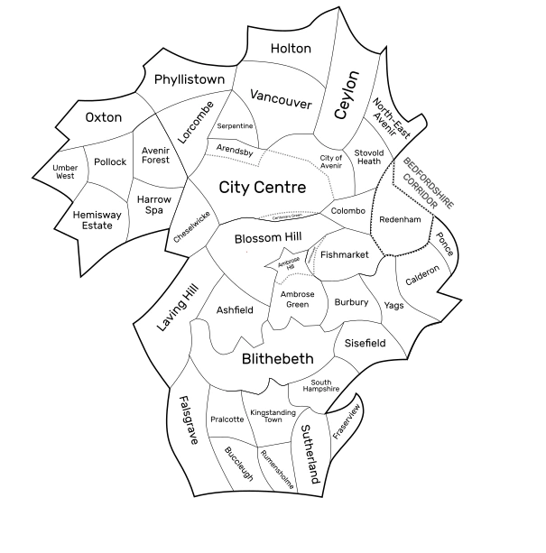
Map of Avenir in 2018. SVG version here
Avenir is separated into 35 different suburbs, which are divided by postal code (i.e. Fishmarket is A4). Each suburb is then divided by precinct; Avenir is separate to the rest of the country in that each precinct shares the same postal code, as opposed to one single road. This skyrockets the prices of precincts by their prestige, as many businesses compete for coveted postal codes. For example, Harper's Heath in Ambrose Hill is postally known as Precinct 12, so its postal code is A2 012. Most postal code numbers are derived from historical origin; Blossom Hill, the first suburb of Avenir by history, is A1, and Fraserview, which was admitted into Avenirian expansion most recently in 1990, is A34. This means, in a postal basis, naming specific addresses is required.
An anomaly is Redenham, which has its own postal code (RM), as it is not part of the same county as Avenir, Lavingtonshire. However, it still follows the Avenir rule of precincts.
List[]
- Blossom Hill (A1): as the Tudor capital of the United Kingdom, Blossom Hill clings onto a huge reserve of Middle Ages heritage, with a total of 1,122 Tudor buildings currently listed. Its largest precinct, Blossom Hill Walls, is a 1400 era castle town, surviving by its military importance in the English Civil War. North-East Blossom Hill, bordering Fishmarket, was sieged in the 30-Day Blitz due to its vicinity with the Severn-Avon crossing, making it an important industrial target. Blossom Hill acquired its namesake after the number of cherry blossom trees lining its older quarters, particularly eminent in Old Town and Blossom Hill Walls. Blossom Hill's population was 296,227 as of 2017.


Castle Juard in Ambrose Hill


Crypt of St. Bartholomew, also in Ambrose Hill


The Cathedral of Avenir, the tallest building in the United Kingdom from the collapse of the Lincoln Cathedral spire in 1549 until 1964
- Ambrose Hill (A2): home to the city's Cathedral, Ambrose Hill is a tiny albeit hugely important suburb home to the city's Cathedral and the only Harrods outside of the capital. As Avenir's geographic centre, it is unofficially the city centre of south Avenir, with its commercial industry taking up 90% of the suburb's jobs and economy. Ambrose Hill, combined with the City Centre, Blossom Hill, Blithebeth, and Vancouver, comprise 85% of the city's tourism base. Despite being the penultimate smallest suburb, it is the fifth most habited, and the most densely populated. Ambrose Hill's population was 50,801 as of 2018.
- Laving Hill (A3): with Lavingtonshire named in its honour, Laving Hill broke off Blossom Hill in the 17th century. Constantly neutral between Blossom Hill and Ambrose Hill disputes, historically it housed the seat of power in Avenir, although much of this has since rotated to the City Centre. Laving Hill's old Tudor town is juxtaposed with huge Art Deco wonders, seeing the majority of its development in the 1920s and 30s after logging became legal in Avenir after a 50 year ban. Laving Hill's enormous size spans mountain ranges reaching to the north-west of Avenir, such as Mount Umber, which begins in Laving Hill. Laving Hill's population was 254,722 as of 2014.


1880s buildings across Lombroso Avenue, Blithebeth. This Gothic architecture is common around the suburb.
- Blithebeth (A4): the largest and most populous suburb of Avenir, comprising 17% of its total land area. Blithebeth, due to its sheer size and economic importance, is the only suburb also classified as a prefecture, with its own governing body which acts under the banner of—but independent from—the larger City Council. Blithebeth is the brainchild of Alfred Blithebeth, following square-based town planning in a very New York-esque matter. Roads are typically wider than anywhere else, with some roads on major thoroughfares having 4 or so lanes; as such, Blithebeth is very car-friendly and often dubbed the "Victorian capital of the road". The main reason for this was that the shopping and trade in and out of Blithebeth at around the turn of the 20th century was so huge as, at this point, Blithebeth was the very geographic centre of Avenir, as much of modern-day North Avenir was undeveloped, and that it lay on a major road from London to Avenir. Major buildings in Blithebeth are typically surrounded by road at each face, being completely detached from any other structure. A lot of roads all meet in a large square, such as Alfred's Friary in Blithebeth's centre. Art Nouveau and Gothic architecture is particularly present in the suburb, such as in the Blithebeth Town Hall, or the most prominent economic street in the city, the Blithebeth High Street. Blithebeth's population was 300,300 as of 2018.
- Fishmarket (A5): after its total destruction in World War II, Fishmarket has a lot of wider roads, making it very car-friendly. Most major shopping precincts are surrounded by motorways, making it attractive for younger audiences. Fishmarket has seen multiple regenerations in a single lifetime; its post-war era was bemocked by criticisms of it being Anti-Avenir and entirely modernist. Only around 2% of the buildings from pre-War Fishmarket survive, with the 3% of the original 5% that survived being swept away due to new development conflictions. Tower blocks, of which there were once over 100 in Fishmarket, have been swept away in favour of flashy new developments, improving the area's skyline. Fishmarket's population was 107,428 as of 2018 (a fraction of what it was in 1940).
- Kingstanding Town (A6): Kingstanding Town is named after the Tudor era village of Kingstanding, which originally flooded into Blithebeth; Blithebeth also shared this namesake. However, after the Alfred Blithebeth takeover of the south of Avenir, the two split. Historic Kingstanding is in the north of the suburb, where the History Monument can be found—inside of which a building of different styles is built every fifty years, having started in 1650. Kingstanding Town's population was 103,782 as of 2016.
- Ashfield (A7): Ashfield is a large middle-class area mostly full of housing. Ashfield has some of the best healthcare and schooling in country, with Ashfield Private Hospital being the listed healthcare unit of royalty, such as Prince Harry. Moreover, the Ashfield Private School, a private secondary school near its border with Ambrose Hill, has a waiting list which many parents join upon the birth of their child due to its efficacy. 1 in 9 of the people on the waiting list get into the school. Due to its borders with Ambrose Hill and Blithebeth and having rows of cheaper housing, Ashfield has been a major immigration centre of Avenir, with a 40% ethnic population. Ashfield's population was 201,443 as of 2018.
- Ambrose Green (A8): at the south border of Ambrose Hill is Ambrose Green, a sprawling suburb full of grand Victorian terraces and popular public schools. As one of the only labour majority suburbs in the city, Ambrose Green is known for kickstarting the LGBT movement in Avenir, and one of the few completely gender-equal areas in Britain to this day, with no gender wage gaps at all. 56% of the jobs in Ambrose Green are taken up by women. Ambrose Green's population was 164,284 as of 2017.
- Burbury (A9): formerly the largest agricultural centre in the city, Burbury has seen mass development since the end of World War II, attracting a younger population. Old Town Cottage Hill is one of the few surviving monuments to its historic farming industry, comprising a small village of old stone cottage buildings. Burbury's population was 86,705 as of 2018 (increasing twofold since 1945).


St. Asaph Hill in Sisefield
- Sisefield (A10): historically home to the rich of Avenir, Sisefield is a huge business hub renowned for the Avenir Film Studios, where many major British productions have been filmed. The Huxley Estate is a prime example of Art Nouveau architecture, primed in many 1800s-era mansions. Lioness, its shopping district, expands in swathes across its centre, historically a circus town. At the periphery of the city, it is only 7km away from Oxford. Sisefield's population was 181,343 as of 2018.


Town centre of South Hampshire
- South Hampshire (A11): primarily built on marshland and swamps, the majority of South Hampshire was reclaimed from harsh and muddy lands. During "The Great Drain", a decade-long process from 1798 to 1808, the land of South Hampshire was drained and dug out, carving out canal systems in the suburb, which it is now famed for. It is named after the county of Hampshire, and is directionally south of the precinct of Hampshire in Blithebeth. South Hampshire's population was 213,284 as of 2017.
- Ponce (A12): Ponce is the smallest and least populous suburb of Avenir. Ponce mainly originated in the 17th century, where the small village was overruled by a cult, headed by Frederick Ponce. His piously-Christian gang was built on the idea of total Christian dominance in England, and, as such, they opposed any Church of England or Catholic believer, on many cases publicly hanging or beheading believers thereof. This disturbed gang of followers to Ponce and his ideologies began to spread across south-east Avenir, albeit prior to possible domination of the city, it was quashed by the Parliamentarians, who made their main breakthroughs to Avenir through Ponce, which was completely unprotected. Frederick Ponce was killed by Parliamentarians in December 1642, after he and his followers were brutally cut down by invaders. Modern-day Ponce is almost completely covered by the Redenham Hills AOB, making it very sparsely populated. The majority of its population lives in Ponce's south-east corner, known for its pub-based nightlife. Ponce is owned and governed by the Frederick Foundation, the only living relatives of Frederick Ponce, who still have dominance over the suburb. Ponce's population was 11,200 as of 2014.
- Calderon (A13): Calderon is a relatively large suburb of Avenir situated in the eastern panhandle bordering Ponce and Yags. Calderon was never developed until the early 1800s due to its isolation from the rest of the city, as Yags didn't join the Avenirian union until 1756, leaving Calderon-Ponce (as the two were both conjoined) as an enclave of Avenir, similar to Umber West. Since then, Calderon has remained heavily agricultural, particularly near Ponce. Calderon is also dissected by several motorways which run in and out of Avenir, leading to construction of new townhouses and flats amongst its vast heaths due to the influence of commuters. Calderon's population was 24,819 as of 2014.


Falsgrave centre
- Falsgrave (A14): formerly New Tuam until 1921, Falsgrave is a huge suburb spanning the south-west corner of Avenir. Known for its music scene, it is the birthplace of British blues music, which mostly developed out of the rich-poor divide between Iversen and Madras, its richest and poorest suburbs. It also has French heritage mostly in the south, believed to have been built by William the Conqueror and his men. Falsgrave's population was 232,780 as of 2017.
- Pralcotte (A15): famed for its wine, Pralcotte is a relatively small Georgian-era town dominated by its vinyards. Its most populous precinct, City Pralcotte, is one of the old towns sucked into Avenirian expansion and is headed by Medieval buildings. Church of England chapels and wooden townhouses provide it with an historic atmosphere. Pralcotte's population was 78,020 as of 2014.
- Buccleugh (A16): an old watering hole, Buccleugh is considered the antithesis of its northern neighbour, Pralcotte. As opposed to their vintage and purified wine, Buccleugh has inexpensive ciders, known for their taste albeit lack of healthiness. Its old village centre is surrounded by walls, dating back to the English Civil War. Buccleugh has some of the unhealthiest residents in Avenir, with an obesity rate of 44%, and an average life expectancy of 74 years and 8 months, both of which can be ascribed to its culturally unhealthy style of living. It is also the most religious suburb of the city, however, with 95% of its population identifying as Christian. Buccleugh's population was 87,981 as of 2014.
- Rumensholme (A17): Named after the Rumens Peoples, a group that can be traced back to the time of Hebrew slavery in Ancient Egypt, Rumensholme is a major Victorian town, known particularly for its history with British Jews and Belgian refugees from World War I. As an historically ethnic suburb of Avenir, Rumensholme was flocked to in masses in the 19th and early 20th centuries due to cheap labour, and open land slots. The first synagogue in Britain was erected in 1872 by Jewish peoples of Rumensholme. The suburb of Capite Est was the first majority-Francophone area in Britain, with a Belgian population of over 10,000 in 1918. Modern Rumensholme is around 85% ethnic, with 72% thereof being Jewish in background. Rumensholme's population was 101,382 as of 2016.
- Yags (A18): the municipal town of Yags is the location of the Lavingtonshire County Council, as well as the seat for the South Avenir Committee. Yags joined Avenir in 1918 after a history of troubles, joining Ponce and Calderon to the contiguous land area. Yags' historic hatred of the city can be ascribed to religious troubles, with Catholicism remaining prevalent in the former royal town, whereas Avenir became Church of England. Avenir had a Tory outcome in all general elections since 1721, with Yags being Whig (later Liberal). Avenir was a major industrial hub; Yags was known for scenes of picturesque heathland and equality in all workers. Modern Yags was mostly built up from 1920, modernising to an extreme extent since its original join with Avenir. Art Deco architecture is evident across the area, notably in the Yags Town Hall, which was rebuilt after demolition in 1922. Yags' population was 140,547 as of 2016.
- Cheselwicke (A19): Cheselwicke is an urbanised inner city area, with a village-esque centre dating back to the English Civil War. Despite its position in the Inner City, Cheselwicke has a mostly homogenous population, mostly to the credit of high home ownership, fairly expensive house prices, and a long history of Irish immigration. Most of Cheselwicke was developed during its industrial boom, which happened notably late in the 1920s, and continued throughout the 20th century until the global industrial shift of the 1970s and 80s. It took up arms manufacturing in World War II, and, unlike Avenir's largest industrial areas of Holton and Fishmarket, survived the war near-unscathed. The fortified walled city of Chesel within its borders is a huge stone castle home to many Tudor houses and shops, headed by a massive fortress, all of which has been publicised for tourism. The stronghold dates back to the Civil War, where it was besieged in 1645 and rebuilt as a housing commune. Cheselwicke's population was 131,344 as of 2017.
- Colombo (A20): another area of mass immigration since the 1950s, Colombo is the only primarily-ethnic suburb of Avenir, whereby 75% of its demography is a first generation immigrant. Much of these people are from the Indian Subcontinent, which forms just over half of its population, and West Asia. In the west, skyscrapers and office buildings on the City Centre's fringes juxtapose precincts of abandoned buildings, which are so prevalent the Colombo district council de-criminalised rooftop hopping, which has since become a popular pastime, albeit now with safety precautions. South Colombo, similar to the west, was decimated in World War II; its border with Fishmarket made it a lining of high-intensity bombing, losing much of its heritage and basic infrastructure, such as its old exposed sewage system. East Colombo is home to some notable demographic anomalies, such as Britain's biggest Libyan population, and being about 90% ethnic, the only precinct of Avenir to be majoritarilly-non-homogenous. Colombo's population was 130,184 as of 2017.
- City Centre (A21): the modern capital of Avenir, the City Centre—formerly known as Queen's Heath—is partitioned between the modern City of Avenir, which was destroyed in the 30 Day Blitz, Tudor and University town of Arendsby, warehouse district Centenary Green, and grand Victorian City Centre itself; this massive expanse is one area with the postal code of A20. Dating back to the 1790s, the City Centre was originally established as an extension to Blossom Hill, which went under the name Queen's Heath. After 1960, its name changed to its current, now that its urban area could act as a "centre" due to destroyed suburban areas in the south. However, there are still large precincts within its area, namely Centenary Green, Arendsby, and the City of Avenir, all of which serve as a reminder to its former situation. The urban population of the city centre (i.e. its population not inclusive of Arendsby, Centenary Green, or City of Avenir) was 120,871 as of 2018, and the metropolitan population was 303,228 as of 2018.
- Arendsby (A22): the University Town of Avenir, Arendsby mostly facilitates the city's university, which was, at one point, the largest university in the world, though this status has long since fallen. The university was originally established as early as the 17th century as the Blossom Hill University, as part of the former Blossom Hill Satellite. Despite initial slows of the Great War of the Southern Dukedoms, the University would continue to grow into an increasingly large, nigh-untouched area of land. The University of Avenir is typically heralded as a third to Oxford and Cambridge, renowned for its history and languages departments, in addition to being arguably one of the most aesthetic campuses in Britain. Arendsby's population is estimated to be as high as 50,000 thanks to student housing as per 2016.
- Stovold Heath (A23): another suburb of Avenir born out of castles and medieval fortifications was the Tudor township of Stovold Heath. Home to more than 30 recognised castles, 13 of which are fully visitable and in good condition, the area is mostly known for meat-based eateries which specialise in the Stovold Patty, a burger characterised by multiple British cheeses and tender meat, and purified breweries locally known for their cider. The eastern rim is almost totally overrun by the Redenham Hills and has one of the final examples of nomadic culture in Britain and the highest number of lumber mills in Britain, at 4 every sq kilometre. In recent years, rightism and Neo-Nazism has been linked to many groups living in Stovold Heath, which lead to over 900 hate crimes in the Stovold Heath border with Colombo, the most ethnically diverse suburb of Avenir. Stovold Heath receives its name from the Tudor age copper mine of Stovold, today part of the suburb North-East Avenir (which split from Stovold Heath in the 1990s as per new housing plans in this region), which is a small salient in the far north-east of the city. Stovold Heath's population was 94,272 as of 2018.
- Vancouver (A24): home to the Avenir Lakeland national park, Vancouver is a mountainous region of north Avenir reputable for its vast forests. Luxury houses are common across the Vancouver lakefront, and the area has a history with North American immigrants, especially Canadians, hence its name. Queen Anne architecture was intercepted by the suburb and is one of the few North American architectural styles seen outside of the continent. Vancouver's population was 58,602 as of 2016.
- Serpentine (A25): with the City Hospital, Serpentine is a large Georgian town interlinked with the City Centre through a series of major roads. It—along with the City Centre and City of Avenir—compose Avenir's financial centres and business outlook. Serpentine is home to the tallest building in the United Kingdom, 10 Holloway Circus, a huge cylindrical building topped by a spire extending to 303m tall, completed in 2012. Serpentine joined Avenir after the expansion of the north-west in the 1960s, which resulted in the redevelopment of its southern rim, although its rural roots remain in its north-east, near Vancouver. Serpentine's population was 72,771 as of 2018.
- Lorcombe (A26): mostly built up between 1910 and 1939, Lorcombe is a large suburban region connecting the modern heathland of the north-west with historic Avenir. After extensive redevelopment in the 1960s and 70s most of the quaint village has been replaced with wide concrete roads connecting to the city centre. Its unfortunate location has meant its ultimate destruction. However, Lorcombe has, in recent years, seen modernisation and exponential business growth to the point where the once-quiet and rural town has become a skyscraper exclave within the city. That said, Lorcombe remains a sufferer of botched Brutalist and functionalist architecture, which scars civilian life and gives it the highest crime rate in Avenir, at 18 thefts per 1,000 people. Lorcombe's population was 98,202 as of 2018, a significant decrease from the 2000 registry of 107,332 residents.
- Holton (A27): the only recorded man-made firestorm in history outside of Germany or Japan struck Holton on January 12, 1941, the single deadliest air-raid on Britain. 96% of Holton was destroyed. Intense incendiary bombing, which proved fatal due to Holton's dense grid town planning, was topped by three megatonnes of Luftwaffe (one fifth of the power of the nuclear bomb over Nagasaki). In post-war times, Holton has suffered more than any other of the five "badly-bombed suburbs" of Colombo, Lorcombe, Holton, Fishmarket, and Cheselwicke, due to its outer circle situation and almost total depopulation after 1945. Private development was at a low due to its distance from the centre and south Avenir, compounded by being blocked by the majority-forest and lakeland Vancouver, leading to council intervention in the 1950s, 60s, and 70s. Highrises and townhouses were commonplace, with the majority of residents housed struggling to find jobs as a result of the minuscule job market after World War II in Avenir, in addition to being placed in Holton after the destruction of their original homes. Jobs in Holton were rare, too; most mines and agricultural plantations were destroyed by bombing, meaning cheap labour factories were Holton's lifeline. However, with an industrial shift in 1975, Holton has seen massive unemployment accompanied by swathes of depopulation, housing crises, and the pulling down of its hundreds of characteristic tower blocks. In recent years, Holton has been listed as one of the worst places to live in Britain and consistently the worst in Avenir. Holton is projected to lose more than half of its current residents by 2040, although new fast train lines and cheap land prices are increasing private development, which was previously rare due to the multiplicity of other opportunities in Avenir. Holton's population was 108,721 as of 2017, minuscule compared to the 1940 registry of 178,900 and 2000 registry of 129,008.
- Ceylon (A28): with heritage dating back to the West Roman Empire era, Ceylon is rivalled by Bath for its collection of Roman heritage in Britain. On top of this, Ceylon was often considered the "owner of Holton" for much of the 19th and 20th centuries, home to thousands of rich factory- and business-owners. Likewise, Ceylon is dominated by sybaritic private housing which encircles its Roman centre. However, a vicinity with the oft-downlooked Holton increases its crime rates and is damaging to its reputation. The northern area of Ceylon is the busiest area of North Avenir, with the City Airport, the second busiest in the UK, behind Heathrow. This gives Ceylon good links with the City Centre, giving it high investments into its quality of life and developments. Ceylon has garnered nicknames like "Suburban Paradise", a 1920s edition of the Daily Mail read, harmonious and vibrant in core. Ceylon's population was 256,262 as of 2018.
- Oxton (A29): the former wealth town joined Avenir recently in 1968, after Avenir's exponential growth in the north-west. The modern and trendy town, home to 3 billionaires and over 100 millionaires, in addition to 2 luxury resorts, Oxton is a town of comfort, growing rapidly to facilitate recent increases in Avenir's economy. An historic village at heart, Oxton's centre is almost wholly Georgian, uniformly juxtaposing the scramble of a distant bustle. Oxton's population was 210,414 as of 2018, tripling in size by the 1940 census of 76,722.
- Harrow Spa (A30): home to the General Post Office since the 17th century, Harrow Spa is responsible for postal services nationwide. Joining Avenirian union in 1780, Harrow Spa has experienced recent spikes of population growth, most recently in the 1960s exceeding 100,000 residents. Largely unremarkable, Harrow Spa has the highest proportion of those above age 40 in Avenir, at 3 in 5 residents being of this age. Harrow Spa's unchanging and ageing population is backed by a higher satisfaction rate than anywhere else in Avenir, showing most of its residents—particularly those from the 1960s and 70s consensus—prefer to stay in the suburb. Harrow Spa's population was 107,100 as of 2018, hardly changed from the 2000 consensus of 101,220.
- Avenir Forest (A31): the first of the New Suburbs of Avenir to be built, Avenir Forest was the first major postwar construction project in Avenir. In order to accommodate a displaced population which had been living in Avenir Forest prefabs for a decade, suburban terraced housing was built in planning not dissimilar to that of the Victorian era. South-east Avenir Forest, a mountainous region, provides a huge outlook over the south and centre of the city, in addition to having cable cars that run down to the bottom. Large modern mansions impose over the view. Avenir Forest's population was 86,890.


A mansion in Hemisway Estate
- Hemisway Estate (A32): the Hemisway Estate was formerly a 1920s casino and luxury town outside of Avenir. Its mass expansion during the Roaring years gave it accolades in and out of Avenir as a holiday destination, with plenty of mountain resorts and luxurious mansions. In 1949, Hemisway joined Avenir under its current name, expanding in the east as an estate. The suburb has expanded more since 1945 than any other suburb, growing from 64,000 residents in May 1945, days after VE Day, to 156,567 in 2018.
- Pollock (A33): alongside Umber West, 2/3 of Pollock's land is taken up by Mount Umber, which peaks just kilometres east from Pollock. The 1/3 of usable land is taken up by forests and agricultural deposits. The popular Boy and Girl Scout programs are popular in Pollock, and its scenery houses a multiplicity of lodges for holidaymakers and residents of Pollock. Cable cars are the second most popular form of transport in Pollock. Moreover, Landry Lane in Pollock, a 1-lane narrow bypass through Mount Umber's Alps, is the most dangerous road in Britain, with 1,800 motor deaths since 1925. Pollock's population was 11,822 as of 2018.


Northern rim of Arte, Umber West


Arte town centre with view of St. Arthur's Church, formerly the Cathedral of the City of Arte until 1796
- Umber West (A34): the peak of Mount Umber in the east of the suburb cuts the majority of Umber West from the rest of Avenir. The scenery of the suburb, however, pulls in more than 50,000 tourists per year; the small town of Arte, a town with 85 churches for less than 20,000 residents, is known for its prominent skyline, covered by tall spires of painted white chapels. Umber West is the coldest habited place in Avenir due to its high altitude above sea level, typically receiving a nickname of Everwinter. The 1540s-dating town existed as an exclave of Avenir from 1610 until 1756, where it joined the city by land after Pollock's unification. Umber West's population was 44,221 as of 2018.
- North-East Avenir (A35): part of Stovold Heath until 1990, North-East Avenir is a product of the housing crises of the late 20th and early 21st centuries in England and Wales. Heavily suburban, North-East Avenir is home to some 80,000 people but remains the greenest area with a population of above 50,000 in the city. In 2010, the suburb was the location of a series of scandalous kidnappings, which included the ultimate deaths of 14 children in North-East Avenir, mostly carried about by the head of its police force. Apprehended after years under his propagated-lead guise in "finding the perpetrator", head of police force in North Avenir, Lucas Danbury, was linked and convicted, currently serving 35 years and execution in a Fraserview prison. North-East Avenir's population was 87,961 as of 2016.
- Fraserview (A36): the newest suburb in Avenir, Fraserview was created in 2001, and is currently expanding rapidly from its current boundaries. By 2050, Fraserview is on track to be twice the size of Blithebeth, meeting the Bedfordshire border with Lavingtonshire, likely split into as many as 6 different suburbia. Fraser Lake, which it is named after, acts as the centre for the developing town, which is surrounded by a few swathes of Georgian villages. Fraserview is heavily car-friendly, hence, 3 motorways run through it into south Avenir. Fraserview's population was 71,650 as of 2018.
- Redenham (RM1): Redenham, whilst strictly separate from Avenir, acts as a metropolitan borough of the larger city and, as a result, is included in Avenirian constitution, postal conformity, and typically, its culture and customs. While its larger area forms the Redenham Hills, heavily-urbanised south-west Redenham forms a large industrial centre and, throughout the postwar development of Avenir, composed the city's standing backbone for much of its production and a deposit of its economy. Redenham's financial centre includes miles of skyscrapers themselves only miles away from the heathland of the Redenham Hills. However, the town's unprecedented growth has not totally been to the benefit thereof; most of Redenham's cultural heritage is under threat or has been demolished. The old Tudor town is all but lost to piles of glass towers, such as The Paperweight, a building whose foundations lie on what once was a Tudor by-street. Nonetheless, Redenham's strong economy and partnership with Avenir cements it as a crucial centre of south-east Avenir. Redenham's population was 262,634 as of 2018.
In popular culture[]
Avenir was ranked the #4 Best City To Live In in 2015 in The Times's Top 500 List of Best Cities in The World to Live In. Its cultural and historical significance in addition to family day outs, local holidays such as in Mount Umber, and convenient housing makes it an ever-more trendy place to live, and the only European city in the Top 4, bested by Melbourne, Wellington, and Singapore. This, The Times stated, is a "major accomplishment", because "few European cities can pull off convenient town planning and still look modern and fresh after hundreds of years. While its victors, such as Singapore, have wide roads, marinas, access to the sea, and on the whole better night life in addition to centralisation, Avenir brings something to the table none of the top 5 can, which is what makes it such a fantastic city."
Countless documentaries have also been made on the subject of Avenir's history of dukedoms, being one of the last cities or principalities in western Europe to have dukes in central power, only abolished until 1730. The existence of the Bellamy dynasty and its survivability despite countless and quasi-unrecoverable damages has also been subject to professional scrutiny.
Twinned cities[]
- Munich, Germany
- Berlin, Germany
- Königsberg, Germany (now Kaliningrad, Russia)
- Rouen, France
- Caen, France
- Zurich, Switzerland
- Burlington, VT, USA
- Bangor, ME, USA
- Providence, RI, USA
- Olympia, WA, USA
- St. George, UT, USA
- Ottawa, ON, Canada
- Vancouver, BC, Canada
- Yangon, Myanmar (formerly Rangoon, Burma)
- Perth, Australia
- Christchurch, New Zealand
Behind the scenes[]
- Main article: /Behind the Scenes